From Environment Canada Outlook Map to Ready-to-Post Alert in Seconds (Canada)
Across Canada, meteorologists and weather communicators rely on Environment and Climate Change Canada (ECCC) for outlook maps, vigilance bullets, and significant weather summaries. Those products are dense, bilingual, and packed with polygons and legend codes — exactly the kind of graphic you screenshot when you want to brief the public quickly. Here's how SkyDraft turns that official map into a publish-ready alert in seconds, using the image alone — the same workflow that already works for U.S. NWS graphics.
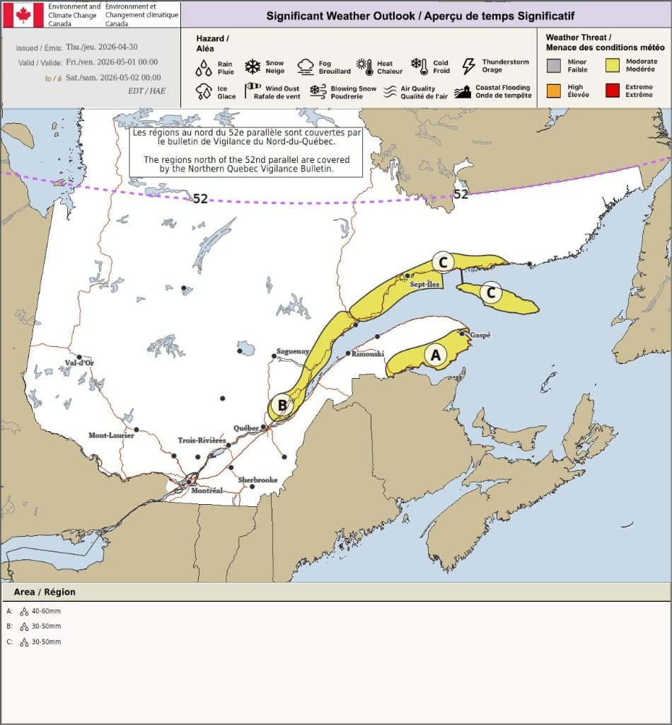
The situation: Significant Weather Outlook — Quebec
The example below is a real Significant Weather Outlook from Environment Canada, covering Québec for a fixed validity window from the bulletin. Maps like this carry everything your audience needs to contextualize risk:
- Hazard icons and the colour scale (minor / moderate / high / extreme)
- Lettered threat regions (zones A, B, C on the peninsula, north shore, and Gulf areas)
- Quantitative rainfall guidance tied to each zone (for example 40–60 mm versus 30–50 mm)
- Temporal validity in local time (EDT), so timing is clear without manual conversion
Translating all of that into a clear social post usually means stopping the forecast workflow, rewriting the legend language for a general audience, and trimming for Twitter/X — while the rain band is already moving.

What SkyDraft does with Canadian products
When you upload the graphic through SkyDraft's photo / map analysis path, the model reads what's on the canvas: agency branding, bilingual titles, shaded regions, rainfall ranges, dates, and the threat level implied by colour and legend. From that single input it produces a cohesive package aligned with Canadian communication habits (English output here; you can generate in French or other languages from the same source depending on your account settings).
- Headline — short, searchable, oriented to outcome (rainy weekend ahead, Québec focus)
- Main post — zone-by-zone structure with threat level and totals, validity line, sensible safety wording (flooding preparedness when rainfall is prominent)
- Short version — character-conscious for X: key zones, totals spread, moderation level
- Hashtags — event- and geography-aware (
#QuebecWeather, community tags like#QCStorm, plus topic tags such as rainfall or flood-watch style labels)

Why this matters for SEO and reach
Search and social audiences often look for agency name + phenomenon + province or city — for example Environment Canada rainfall outlook Québec, or moderated French queries mirroring bulletin titles. Leading with the official framing (outlook validity, rainfall ranges, moderated threat) anchors your post in factual language that matches how people validate claims. SkyDraft preserves those anchors while rewriting for skim readers: bullets, bold zone labels, and a single clear call to invite updates or eyewitness reports — which helps engagement signals on platforms without diluting attribution to the source graphic.
Structure matches the threat geometry
Eastern Canada outlooks routinely split maritime, riverine, and insular exposures. A post that respects those same lettered partitions helps locals answer "does this apply to Gaspésie versus the Middle North Shore?" without opening the PDF on a phone.
Character discipline for X still holds
Keeping a short synopsis under roughly 280 characters leaves headroom for a link back to Environment Canada radar or vigilance hubs when you add one manually — the generator handles the condensation so you aren't edit-fighting commas at midnight.
Canadian data, familiar workflow
SkyDraft already supports live Environment Canada ingestion for form pre-fill alongside NOAA/NWS. Pairing that with outlook image uploads means broadcast, municipal emergency social teams, Réseau BMS-style communities, and independent creators can operate from the same bulletin art their audience recognises from météo.gc.ca — not a meme template.
Who is this for?
- Public safety and municipal communicators — bilingual regions need fast English or French drafts originating from identical ECCC screenshots.
- Broadcast and digital meteorologists — turnover from map wall to TikTok caption without a junior producer retyping polygons.
- Outdoor and marine communities — guides, charters, fishers translating outlooks posted for the Gulf and Estuary into timelines their clients grasp.
- Storm-interested creators — responsible sharing with correct validity and totals, hashtags that surface in Québec-centric feeds.
Try it with your next bulletin
Grab the next Environment Canada outlook, alert map, or impact graphic dropped on weather.gc.ca — screenshot or export the PNG, upload it, and generate. Combine with SkyDraft live Canada data pulls when you're building a longer thread or newsletter.
The free plan includes 10 generations per month — no credit card required — so you can test on real spring rainfall and summer severe setups before the busiest season peaks.
— The SkyDraft Team
Ready to try SkyDraft?
5 free generations per month. No credit card required.
Create your free account →